 |
||
| Huygens and Cassini - in search for a
correlation |
||
October 19-27, 2005
|
||
|
||
Both space probes, Cassini as well as Huygens, have mapped the "Adiri" region on Titan were Huygens made its descend, but a definite correlation between these two maps has not been figured out (or has not been published) until today. After I finished the first versions of my surface mosaic I also tried to figure out this correlation, but failed to find clear agreements of surface structures with the given calibration. It seemed that the assumption of a calibration error of a relatively large factor of 2.5 could fix that (see here), but now, on the basis of new informations, it seems to be unlikely that such a large calibration difference is possible. My original idea was, that the height above ground values, calculated with the help of a timer and an atmosphere model, could contain mistakes due to unexpected upcurrents that may have delayed Huygens descend. Against such a calibration error now speaks that: - the Radar-Altimeter is reprted to be in agreement with the Timer-Altimeter for the last part of the descend - Radar Science (tracking the probe with radio telescopes around the world) could reconstruct Huygens path, and it is reported to be in agreement with the Timer Altimeter data. The reason for the disagreement between the two surface maps, Cassini and Huygens, now is supposed to arise from the different imaging wavelength of the instruments: Huygens DISR was working at a broadband range from red to near infrared, 660nm - 1000nm, while the Cassini ISS had to obtain the images around a center wavelength of 938nm (CB3 filter) to penetrate the thick smog of Titan's atmosphere. When searching for a possible correlation on the basis of my mosaics, you should always keep in mind that it is very difficult to make a correct large scale albedo adjustment in the mosaics. I am quite shure that north of the bright "highland" there is a darker area, resulting in this triangular shape of the highland region, but it may well be that my photometric correction leaves it slightly darker than it is in reality. For the upcoming close Flyby of Titan, the T8 Flyby scheduled for October 28, a Radar Swath of the Descend area of Huygens is planned. Perhaps this independent imaging method will lead to a definite decision concerning the missing correlation. |
||
 |
||
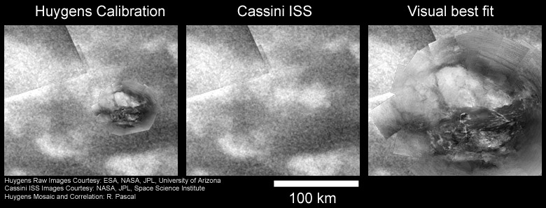
| Figure 1: Center: Cassini ISS image, taken at a wavelength of 938nm. Left: Huygens mosaic in original size calibration as inset in the ISS map. This position represents the best agreement of surface features I could find, but the overall agreement is poor. Right: My earlier attempt to come to an agreement of surface structures, assuming a calibration error. The agreement of surface structures seems to be much better, but recent informations should rule out such a large calibration mismatch. |
||
| Another
suggestion for a placement of the mosaic bases on Larry Soderblom’s
talk on the DPS conference. He presented attempts to find the correct
rotational orientation of the images by radio science. The rotational
asymmetry of the field of Huygens low gain antenna is used to determine
the direction the probe was looking for every raw image. With that new
orientation for the mosaic, that leaves it rotated by about 15°
counter-clockwise, the best fit should be as presented in Figure 2. The
analogy still is not very good, but it is slightly better than in
Figure 1 left. |
||
 |
||
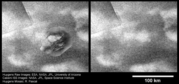
| Figure 2: Right: Cassini ISS image, taken at a wavelength of 938nm. Left: The Huygens Mosaic in original size calibration, in a rotational orientation that bases on the radio science results. |
||
| A
third possibility is that a pale, triangular shaped feature visible in
the Cassini ISS images near the Huygens landing site corresponds to the
large triangular shaped "Highland" feature in the mosaic (Figure 3).
The overall correspondence is even better than in the other placements.
I was a little bit sceptical regarding this position in the beginning,
since I wondered if it would not be too far off from the originally
published landing site, but after examining the images again and
again, now this position turns out to be one of my favorites... |
||
 |
||
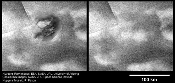
| Figure 3: Right: Cassini ISS image, taken at a wavelength of 938nm. Left: Huygens Mosaic in a rotational orientation that bases on the radio science results, with a placement about 50km north-west of the placement in Figure 2. |
||
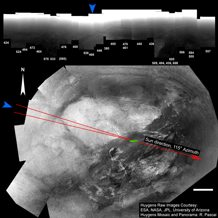
| Figuring out the North-Direction In conection with my attempts to find the correct placement of the Huygens mosaic within the Cassini images, a detail in one of my early mosaics, "Huygens distant view" cought my eye. There is a distinct increase in Horizont brightness around the images 476, 400, 526, 466, 446 and 455 (blue arrow). My assumption is, that this increased atmosphere brightness results from the scattering properties of the atmosphere and marks the direction opposite to the sun. I do not think that it is an artifact, since it can also be well seen as an inclined horizon brightness when looking at the SLI raw images, the numbers 476, 455 and 400 for instance. With the information where Huygens approximately was when shooting the corresponding images (green ellipse) the sun direction can be determined with an uncertainty of perhaps +-3 degrees (the two red lines in the upper left). The resulting rotational orientation (north direction) very well fits the new orientation reported recently, by Larry Soderblom for instance. |
||
 |
||
| Figure 4: Top: Panorama "Huygens distant view" with a distinct increase in atmosphere brightness around the SLI frames 476 to 455 (blue arrow). Bottom: Mosaic with the direction of the increased atmosphere brightness (blue arrow) and the position where Huygens was when obtaining the corresponding images (green ellipse). With these informations we can determine the sun direction (red arrow) and correct north orientation of the mosaic. |
||
Related articles: "Strong evidence for a visible Huygens to Cassini correlation" March 20, 2005 "Where did Huygens descend?" February 18, 2005 "Scaling the views" February 18, 2005 |
||
| |